Gis Applications
Advertisement
Quantum GIS Tethys v.1.5-r13926-1
The Quantum GIS Tethys repository contains a lot of software from OSGeo projects. Quantum GIS Tethys and all dependencies are included, along with Python, GRASS, GDAL, etc.
Advertisement
My World GIS v.4. 1. 2011
My World GIS™ is a Geographic Information System (GIS) designed specifically for use in middle school through college classrooms.
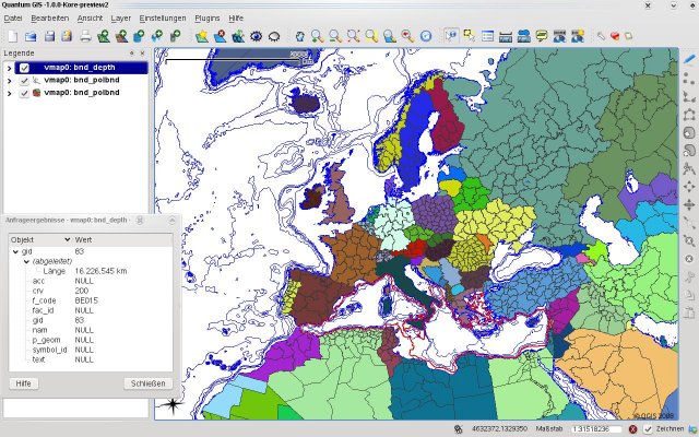
Quantum GIS v.1.8.0
Cross-platform and user friendly Open Source Geographic Information System (GIS). Quantum GIS (QGIS) is a user friendly Open Source Geographic Information System (GIS) that runs on Linux, Unix, Mac OSX, and Windows. QGIS supports vector, raster,

Grass GIS for Mac OS X 6.4.1-3 v.3
Commonly referred to as GRASS, this is a free Geographic Information System (GIS) used for geospatial data management and analysis, image processing, graphics/maps production, spatial modeling, and visualization.
Quantum GIS form Mac v.1.8.0
QGIS supports vector, raster, and database formats and lets you browse and create map data on your computer.
Simple dictionary applications
Applications allow users to use free bilingual dictionaries offline. You can download free dictionaries at: http://www.dicts.info/dictionaries.php and at: http://www.dicts.info/uddl.php . You can create and download any bilingual dictionary from the
Business Applications Architect
BA Architect offers great benefits to application developers working with ADO.NET compatible data sources, including MS Access, MS SQL Server and Oracle. Its advanced technologies help rapidly create and integrate your database applications into existing
Position Transducers Applications
Accent Novotechnik Position Transducers Applications are described with categories - Linear Contactless, Linear Potentiometric, Rotary Sensors. Using this Application, users can learn how and where to apply the sensors in Industrial Applications.
Total GIS Converter v.1.5
Total GIS Converter is a powerful converter of GIS files. It converts AEP, GRD, ADF, E00, FLT, APR, SHP, DXF and many other GIS formats to TIFF, PNG, JPEG, BMP. Along with conversion it can scale and resize your files. Download your free copy now!
ManageEngine Applications Manager
Applications Manager monitors performance and availability of application servers (JBoss, WebSphere, Oracle AS, WebLogic, Tomcat, WebLogic Integration, Microsoft .NET), Transactions(J2EE Web Transactions, Java Runtime), databases (MySQL, SQL
Communication Applications Software for the Classroom
This 12-unit interactive, multimedia program covers interpersonal, group, and public speaking communication. Communication Applications contains complete tracking of student progress, for business communication, classroom labs, or the home school. One